
Topographical Surveyors: What Is a Topographical Survey and Why Do You Need One?


Whether you are an architect preparing plans for a new development, a developer assessing the potential of a site, a town planner considering planning constraints, or a homeowner planning an extension, accurate information about the existing site is one of the most important starting points.
Before you begin designing, you need to understand what is actually there.
Ground levels, buildings, walls, fences, trees, drainage features, roads, access points and other physical features can all influence the design and cost of a project. Relying on estimated measurements, outdated plans or information taken from online mapping can result in designs that do not accurately reflect the site.
This is where professional topographical surveyors can help.
A topographical survey provides a detailed and accurate record of the existing physical features and levels of a site, giving architects, engineers, developers and other professionals reliable information to use when designing and planning a project.
What Is a Topographical Survey?
A topographical survey, sometimes referred to as a topographic survey or land survey, records the physical features and levels of a site.
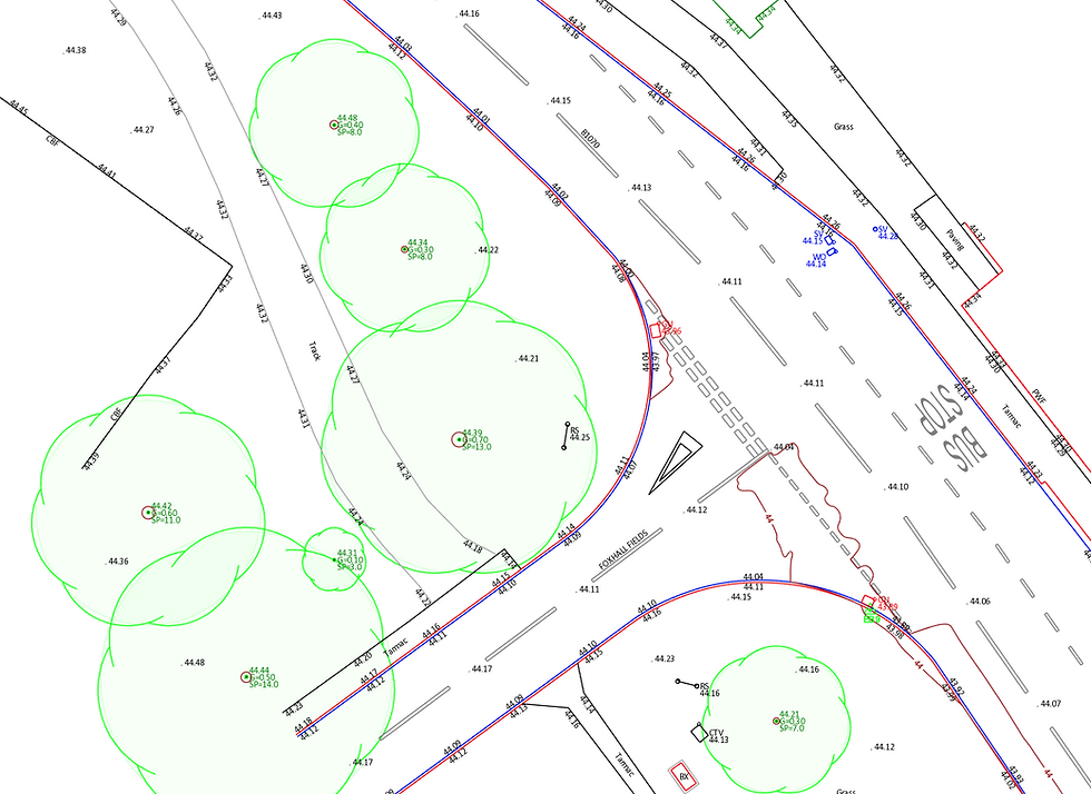
Unlike a simple site measurement, a professional topographical survey can provide a detailed representation of both the natural and man-made features found within the survey area.
Depending on the requirements of the project, this may include:
Ground levels and spot heights
Contours and changes in ground level
Buildings and other structures
Walls, fences and hedges
Trees and vegetation
Roads, kerbs and pavements
Footpaths and access routes
Drainage features and manholes
Ditches, banks and embankments
Utility features visible at ground level
Electricity poles and overhead cables
Gates and site entrances
Hardstanding and other surfaced areas
Significant changes in ground conditions
Adjacent features that may affect the proposed development
The exact information collected will depend on the size, location and intended use of the survey.
What Do Topographical Surveyors Do?
Professional topographical surveyors use specialist surveying equipment to accurately measure the position and elevation of features across a site.
At Landtech Surveys, the equipment and surveying methods we use can be adapted to suit the individual project.
For example, a smaller residential site may be surveyed using GNSS and conventional survey equipment, while larger or more complex sites can benefit from a combination of GNSS, laser scanning and drone mapping.
The resulting survey data can then be processed to create detailed CAD drawings, normally supplied in formats such as DWG and PDF, allowing architects, engineers and other professionals to use the information directly within their design software.
Why Do You Need a Topographical Survey Before Designing?
1. Design From Accurate Existing Site Information
One of the main advantages of commissioning a topographical survey before starting your design is that your architect or designer is working from measured information rather than assumptions.
Ground levels can have a significant influence on the design of a building or development.
For example, a sloping site may affect:
Finished floor levels
Building heights
Foundations
Retaining walls
Drainage
Vehicle access
External landscaping
Cut and fill requirements
Having accurate information at the beginning of the project can therefore help identify potential problems before detailed design work begins.
2. Help With Planning Applications
Many development and planning projects require accurate information about the existing site.
A topographical survey can provide the existing ground levels and physical site features needed to help architects and planning consultants prepare their proposals.
Rather than attempting to establish levels from existing mapping or estimates, the design team can work from a survey carried out specifically for the site.
The survey can also be used alongside architectural drawings to help demonstrate how a proposed development relates to the existing ground conditions and surrounding features.
3. Reduce the Risk of Costly Design Changes
Discovering an important site feature after the design has already been prepared can result in additional work.
For example, a previously unidentified change in level, drainage feature, retaining wall or access restriction could require elements of a design to be changed.
A detailed topographical survey provides the design team with much more information at the beginning of the project, helping reduce the risk of unexpected site conditions affecting the design later.
4. Understand the Existing Levels
Levels are one of the most important parts of a topographical survey.
Knowing the relationship between different areas of a site can help determine how a proposed building, road, access or other structure can be positioned.
For developments on sloping ground, accurate levels can be particularly important.
Survey data can be used to create contours and digital terrain models, giving designers a much clearer understanding of the shape of the existing land.
5. Identify Physical Site Constraints
Aerial imagery and online mapping can provide a useful overview of a site, but they do not replace a measured topographical survey.
A site survey can identify physical features that may not be visible or accurately represented on mapping.
These could include:
Changes in ground level
Drainage channels and ditches
Boundary fences and walls
Trees and hedges
Existing structures
Access points
Kerbs and footpaths
Utility features
Overhead cables
Retaining structures
Recording these features before design begins gives the project team a much better understanding of the existing site.
How Do Topographical Surveyors Measure a Site?

Modern surveying technology allows topographical surveyors to collect large amounts of accurate information efficiently.
At Landtech Surveys, we use a combination of surveying technologies depending on the requirements of each site.
GNSS Surveying
GNSS equipment allows surveyors to accurately establish the position of measured features using satellite positioning technology.
Our Trimble R12 GNSS receiver can be used to establish survey control, measure site features and connect surveys to the appropriate coordinate system.
GNSS is particularly useful for open areas where satellite visibility is good.
Total Station Surveying
Total stations provide highly accurate measurements of angles and distances.
They can be particularly useful where satellite reception is restricted, such as around buildings, trees or other obstructions. Our Trimble robotic total station is a one man instrument designed for accuracy and speed.
3D Laser Scanning
Laser scanning can capture a very large amount of three-dimensional information in a relatively short period.
Our Trimble X7 laser scanner can be used on sites where a high level of detail is required, including buildings and complex structures.
The resulting point cloud can provide a detailed three-dimensional record of the existing environment.
Drone Mapping
For larger areas, drone surveying can provide an efficient way of capturing aerial information.
Our RTK-enabled DJI drone can capture aerial imagery which can then be processed to produce an orthophoto and other survey data.
Drone mapping can be particularly useful on large areas of land, construction sites, agricultural land and areas where accessing every part of the site on foot would be time-consuming.
The drone does not replace ground surveying where high accuracy is required. Instead, drone mapping and ground survey techniques can be combined to provide a more complete picture of the site.
Combining Surveying Technologies
One of the advantages of using an experienced topographical surveyor is that the surveying method can be selected according to the site rather than attempting to use one technology for every project.
For example, a larger site may benefit from drone mapping to capture the overall area, GNSS to establish accurate ground control and conventional surveying to measure features requiring additional detail.
Similarly, a building survey may benefit from laser scanning while GNSS is used to establish the survey's position within the wider coordinate system.
The result is a survey designed around the requirements of the project.
Examples of Topographical Surveys by Landtech Surveys
135,000m² Site and 600m of Highway – Keyworth, Nottinghamshire

Landtech Surveys carried out a topographical survey covering approximately 135,000m² of farmland and around 600 metres of highway in Keyworth, Nottinghamshire.
The site was being considered for potential future development.
The survey recorded features including field boundaries, hedgerows, trees, ground levels, road features, manholes, gullies, utility poles and other site information.
Drone mapping was used to provide an overview of the site, while GNSS surveying was used to accurately measure key ground features and establish survey control.
7,000m² Residential Site – Chesterfield, Derbyshire

For a residential project in Chesterfield, Landtech Surveys surveyed gardens and an adjoining field covering just over 7,000m².
The survey was required to provide accurate existing information for an architect preparing a design proposal.
A combination of 3D laser scanning, drone mapping and GNSS surveying was used to efficiently capture the site and surrounding features.
5.5-Acre Agricultural Site – Ashbourne, Derbyshire

Landtech Surveys also completed a topographical survey covering approximately 5.5 acres of farmland near Ashbourne, Derbyshire.
The survey included ground levels, boundary fences and hedges, trees, banks, ditches, overhead lines, electricity poles, access tracks, farm structures and the adjacent highway.
A DJI RTK drone was used to help map the site, with GNSS surveying used for ground control and additional ground features.
The survey was completed on site in a single day, with the completed CAD drawing supplied to the client shortly afterwards.
What Do You Receive From a Topographical Survey?
The final survey deliverables will depend on the requirements of the project.
Typical outputs from Landtech Surveys can include:
2D CAD Survey Drawings
DWG CAD drawings can be supplied for use by architects, engineers, planners and other professionals.
The survey drawing can contain the measured site features, levels, contours and other information collected during the survey.
PDF Survey Plans
PDF versions provide an easy-to-view copy of the completed survey and can be useful for planning discussions, quotations and project records.
3D Data and Point Clouds
Where appropriate, three-dimensional survey data and point clouds can also be supplied.
These can be particularly useful for complex sites, buildings, engineering projects and applications requiring detailed spatial information.
Orthophotography
Drone surveys can also produce high-resolution orthophotography, providing an aerial image of the site that can be used alongside the measured survey information.
Topographical Surveyors Near Me
If you are searching for “topographical surveyors near me”, it is worth considering more than simply the distance between the surveyor and your site.
The surveyor's experience, equipment, understanding of the project requirements and the format of the final survey data are all important considerations.
Landtech Surveys is based in Belper, Derbyshire, and undertakes topographical surveys throughout Derbyshire, Nottinghamshire, the East Midlands and across the UK.
We regularly work with homeowners, architects, developers, planning consultants, contractors and other professionals who require accurate information about existing site conditions.
How Much Does a Topographical Survey Cost?
There is no single price for a topographical survey because every site is different.
The cost can depend on factors including:
Size of the survey area
Site location
Terrain and vegetation
Number of features to be surveyed
Required level of detail
Accessibility
Whether buildings need to be surveyed
Whether drone mapping or laser scanning is appropriate
Required deliverables and CAD formats
Survey control and coordinate requirements
A small residential garden may require a very different survey approach from a large development site or agricultural holding.
For this reason, we recommend providing as much information about your project as possible when requesting a quotation.
Choosing the Right Topographical Surveyor
The right surveyor should be able to understand what information your project actually requires rather than simply carrying out a standard survey.
Before commissioning a survey, it is worth considering:
What is the survey being used for?
A survey for a house extension may have different requirements from one being prepared for a large development.
What information does your architect or engineer need?
Providing the surveyor with the project requirements can help ensure the correct features and levels are captured.
What CAD format do you require?
If your architect or designer needs a DWG file, confirm that the survey can be supplied in a format compatible with their software.
Does the survey need to be tied to a coordinate system?
For larger projects, establishing the survey on the appropriate national or local coordinate system can be important.
How quickly do you need the survey?
Agree the expected site visit and drawing turnaround before commissioning the work.
Why Choose Landtech Surveys?
Landtech Surveys has more than 20 years of experience providing land surveying services to clients across Derbyshire, the East Midlands and throughout the UK.
We combine traditional surveying techniques with modern technology including:
Trimble R12 GNSS surveying
Total station surveying
Trimble X7 3D laser scanning
RTK drone mapping
CAD and 3D survey processing
This allows us to select the most appropriate surveying method for the individual site.
Our aim is straightforward: provide accurate, useful survey information that gives our clients a reliable starting point for their project.
Whether you need a topographical survey for a house extension, planning application, agricultural development, commercial project or larger development site, we can discuss your requirements and provide a quotation based on the specific site.
Request a Topographical Survey
If you are looking for experienced topographical surveyors in Derbyshire, Nottinghamshire or the East Midlands, Landtech Surveys can help.
Contact us to discuss your project and find out what information we would recommend surveying.
Landtech Surveys Telephone: 07795 286 130
Website: www.landtechsurveys.co.uk
Get in touch today for a free, no-obligation quotation for your topographical survey.
Frequently Asked Questions About Topographical Surveys
What is a topographical survey?
A topographical survey is a detailed measured survey that records the physical features and ground levels of a site. It can include buildings, boundaries, roads, trees, drainage features, walls, fences, utilities and changes in ground level.
Why do I need a topographical survey?
A topographical survey provides accurate existing site information for architects, engineers, planners, developers and other professionals. It helps them design a project around the actual conditions of the site rather than relying on assumptions or outdated information.
How accurate is a topographical survey?
The achievable accuracy depends on the equipment, survey method, site conditions and specification of the survey. A professional surveyor should be able to advise on the appropriate survey methodology and accuracy required for your particular project.
Do topographical surveys show boundaries?
A topographical survey can record the physical position of fences, walls, hedges and other boundary features visible on site. However, a topographical survey should not automatically be interpreted as determining the legal ownership or legal position of a boundary. Where the legal position of a boundary is in question, a specific boundary survey may be required.
Can a topographical survey be used for planning permission?
Topographical survey information can be used by architects and planning professionals when preparing planning proposals. The exact survey requirements will depend on the proposed development and the requirements of the relevant planning authority.
How long does a topographical survey take?
The time required depends on the size and complexity of the site. Smaller sites can sometimes be surveyed within a few hours, while larger or more complex sites may take a full day or longer.
How much does a topographical survey cost?
The cost varies according to the size and complexity of the site and the information required. Landtech Surveys can provide a quotation based on the specific requirements of your project.
Do you provide topographical surveys in Derbyshire?
Yes. Landtech Surveys is based in Belper and provides topographical surveys throughout Derbyshire, including Derby, Chesterfield, Matlock, Ashbourne and surrounding areas, as well as Nottinghamshire, the wider East Midlands and nationwide.


Comments